Walking through the sites of terrorism: a walk proposed by Yoshinori Niwa, 2014

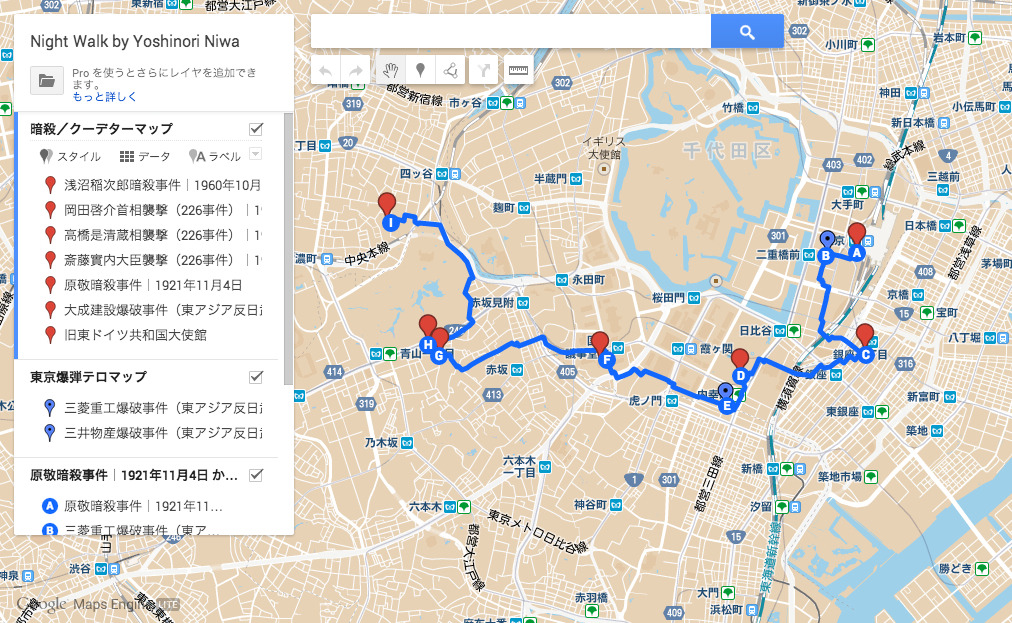
Google Mapsによる歩行ルート
Walking route on Google Maps
東京でテロ現場を歩く
2014, リサーチツアー
1930年代から1970年代までの暗殺現場、爆弾テロ現場を主要ポイントとした東京駅から四谷までの8kmの道程を真夜中の時間に歩く。東京東部に位置する東京駅周辺では、左翼運動から生まれた《東アジア反日武装戦線》よる1974年の連続企業爆破事件の事件現場を巡り、徐々に東京西部に移りながら右翼思想に影響を受けた陸軍将校らが政府中枢を襲撃したクーデター未遂事件《226事件》の事件現場の数カ所を巡ります。多くの現場はすでに、ビルの改装や移転、土地売却を経て事件の面影もなくなり、知らなければ全く気づくことなく生活することが可能になった。過去の歴史的事件を地図上で重ねて、実際に左から右に移動してみることで「過去の見えなさ」を見ることを主要な目的とした、作品未満のリサーチ・イベント。
Walking through the sites of terrorism: a walk proposed by Yoshinori Niwa
2014, Research tour
In this tour, participants will be walking through an 8 km-route during midnight from Tokyo station to Yotsuya in search of sites of terrorist attacks and assassinations which took place between the 1930s to 1970s. Around Tokyo station, the east part of the city, the group will visit sites where a series of terrorist bombings at corporate buildings were conducted in 1974 by a left-wing terrorist organization East Asia Anti-Japan Armed Front. The walk will then continue to west tracing the sites of the February 26 Incident, which was an attempted coup d’état to attack the nerve center of the government organized by the right-wing Imperial Japanese Army (IJA) officers. Many of those sites are hardly recognizable today due to the renovation or relocation of the buildings or land selling, and it is not difficult to live in the city without noticing these sites unless you already knew. This night walk is a research event, not yet formed into a project, in an attempt to see the “invisibility of the past” by projecting the historical incidents on a map and actually walking from the left to the right.
Artist Text Statement